2012
NS3977 : A slime mould - Cribraria cancellata
taken 12 years ago, near to Renton, West Dunbartonshire, Scotland
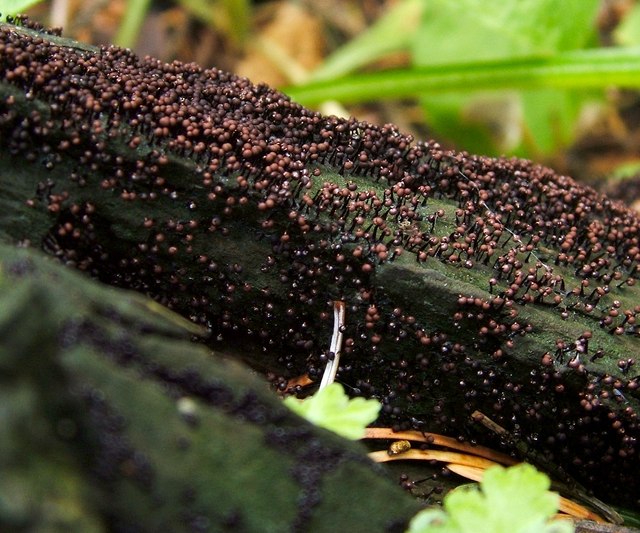
A slime mould - Cribraria cancellata
[Some works refer to this species by the synonym Dyctidium cancellatum.]
This large clustered development was at the base of a conifer beside a NS3977 : Path through the woods, not far from a large mound (NS3977 : Mound beside the River Leven); the slime mould was only present in those parts of the base of the tree where the bark was missing (decorticated wood is the technical term).
The stalked structures (sporangia) are individually about 2-3mm tall. The structure at the top of the stalk has an elegant pattern of longitudinal ribs, evident under magnification (but not in the present photograph, which is intended to show only what is apparent to the unaided eye).
This fairly common species is mainly encountered on the wood of conifers, but it is occasionally found on other kinds of wood.
See NS3977 : A slime mould - Stemonitis species, taken on the same day, for an explanation of why slime moulds were abundant on this occasion.
 Map © Crown Copyright")
TIP: Click the map for more Large scale mapping
- Grid Square
- NS3977, 336 images (more nearby 🔍)
- Photographer
- Lairich Rig (more nearby)
- Date Taken
- Friday, 6 July, 2012 (more nearby)
- Submitted
- Wednesday, 11 July, 2012
- Subject Location
-
OSGB36:
 NS 3961 7791 [10m precision]
WGS84: 55:58.0394N 4:34.2801W - Camera Location
-
OSGB36: NS 3961 7791
- View Direction
- Southeast (about 135 degrees)